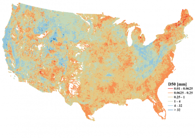
Median Bed-Material Sediment Particle Size Across Rivers in the Contiguous US
Bed-material sediment particle size information is critical for understanding and modeling riverine sediment processes. However, such data is only sparsely available even in the U.S., preventing regional-to-global scale simulation of riverine sediment processes in a changing environment. This study developed a new national map of median bed-material sediment particle size over the contiguous U.S. by utilizing a state-of-the-art machine learning method and site observations. It is shown that this new map captures the spatial variability of sediment particle size in a statistically robust way.
It enables modeling suspended, fine-size sediment discharge in the land-river-ocean continuum and, more excitingly, particulate carbon and nutrients that are attached with fine-size sediment particles. It can also be used for large-scale geomorphological modeling to track the spatial shifting of river channels, river deltas, and coastal lines in the U.S.
Existing river-bed sediment particle size data are sparsely available at individual sites. We developed a continuous map of median river-bed sediment particle size over the contiguous U.S. corresponding to millions of river segments. This national map was derived with a predictive model based on the latest artificial intelligence methods and the observed sediment and other data mostly from the U.S. Geologic Survey. This map is useful for research in large-scale river sediment using model- and data-driven approaches, teaching environmental and earth system sciences, planning, and managing floodplain zones, etc.

