
About Earth System Model Development
Mission and Priorities
The Earth System Model Development area supports innovative and computationally advanced earth system modeling capabilities, with the ultimate goal of providing accurate and computationally advanced representations of the fully coupled and integrated earth system, as needed for energy and related sectoral infrastructure planning. Key examples of critical information for energy include accurate projections of water availability, drought incidence and persistence, extreme temperature, storminess, opening of the Arctic Ocean, and sea level and storm-surge in coastal regions.
To provide this information, considerable effort is needed to develop optimal-fidelity earth system simulations, with suitably accurate representations of atmospheric dynamics, clouds and chemistry, ocean circulation and biogeochemistry, land biogeochemistry and hydrology, sea ice and dynamic land ice. In each case, human systems, such as water management and land use, are integral components of the modeling system.
Earth System Model Development utilizes the mathematical and computational expertise within the DOE national laboratories to develop efficient, accurate and advanced algorithms for earth system processes and to improve model initialization, optimal component coupling and uncertainty of system simulations, and model projections. The aim is to optimize earth system codes to run efficiently on DOE’s most advanced exascale and post-exascale computer architectures, using modern and sustainable software and workflows, providing a high-resolution coupled earth system simulation capability that is vital for accurately understanding how the earth system evolves and also supporting DOE energy planning responsibilities.
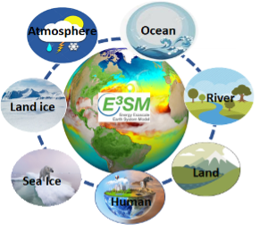
Central to the Earth System Model Development activities is the Energy Exascale Earth System Model (E3SM) project, which focuses on further development of a scale-aware hyper-resolution capability that efficiently runs on DOE high-performance computers, simulating the near-term past (for model validation) and future (3 to 4 decades) in support of the DOE science mission. The E3SM further employs regional refinement using advanced unstructured mesh methodologies in order to provide ultra-high resolution to resolve critical physical and dynamical phenomena. The E3SM development effort strives to further design the code to optimize performance on current and future DOE HPC architectures.
E3SM targets the research community’s more challenging science questions, e.g., involving cloud-aerosol interactions, ice sheet physics, biogeochemistry, hydrology, ocean eddy dynamics, and the interdependence of low-frequency variability and extreme weather. E3SM is a digital replica of the earth system which can be used to understand and predict: 1) impact of the natural world on US energy systems; 2) subseasonal to decadal weather patterns; and 3) likelihood of costly weather disasters (e.g. hurricanes, atmospheric rivers, and heatwaves).
E3SM leverages DOE’s bleeding-edge computational advances to lead the world in earth system modeling (ESM): E3SM 1) won the 2023 Gordon Bell prize (top honor in super-computing) for being the first ESM to run on an exascale computer; 2) continues exerting leadership in performance-portable software for DOE next-generation architectures and 3) is now leveraging AI to enable simulations at unprecedented resolution for improved accuracy and performance.
Other activities supported by Earth System Model Development complement and enhance E3SM, including the development of potential future-generation capabilities within the Scientific Discovery through Advanced Computing (SciDAC) program and supporting collaborative and community codes that are developed and used by multiple scientific communities. As a core ESM capability in the EESM framework, E3SM serves as a foundation of Dynamical Digital Testbed by tailoring and demonstrating the capability for credible hyper-resolution model output relevant for the test-beds and with AI tools, making it more accessible and flexible for use.
The Earth System Model Development area coordinates its activities with modeling programs at other federal agencies, including the National Science Foundation (NSF) through the CESM project, National Oceanic and Atmospheric Administration (NOAA), National Aeronautics and Space Administration (NASA) and interagency working groups.