Improving Forecasts of Tropical Clouds and Precipitation Using Satellite Observations
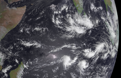
Tropical clouds play a dominant role in the Earth’s water and energy cycles, but they are not well sampled by in-situ observations over the tropics covered broadly by oceans. Using a state-of-the-art data assimilation algorithm, scientists integrated high spatiotemporal satellite infrared observations with computer forecasts over the Indian Ocean. With improvements to the data assimilation method, they found that ingesting the satellite observations into forecast models generally improved the analysis and forecast of clouds and rainfall over tropical oceans
As infrared satellite measurements have frequent and global coverage, maritime weather forecasting and analysis can be greatly improved by assimilating these observations into numerical models. Previous studies assimilating infrared observations in models focused mainly on forecasting tropical cyclones and mid-latitude severe weather with well-organized patterns. This study showed that better reanalysis can also be generated for the noisier tropical convection using improved satellite data assimilation technique. The improved reanalysis datasets can be used to deepen our understanding of the roles of clouds in regional and global climate.
In this study, water vapor channel brightness temperature (WV-BT) observations from the geostationary Meteorological Satellite 7 (Meteosat-7) were assimilated into a 50-member Weather Research and Forecasting ensemble using a newly developed stochastic ensemble Kalman filter over the equatorial Indian Ocean. Systematic comparisons of the experiment against a control setup revealed that assimilation of WV-BT using the new data assimilation method improved the analyses and forecasts of tropical clouds as well as their large-scale environment. Furthermore, forecasts initiated from both model setups indicated that assimilation of WV-BT improved rainfall forecasts at 3 to 6 hours lead times.

