Water Cycle and Climate Extremes Modeling
Project Team
Principal Investigator
Research Element Lead
Project Participant
External Collaborator
The Water Cycle and Climate Extremes Modeling (WACCEM) Scientific Focus Area represents a sustained effort to advance predictive understanding of water cycle processes and their subseasonal-to-multidecadal variations and changes through foundational research using models, observations, and novel numerical experiments and analysis methods. With the ultimate goal of improving the predictability of water availability and understanding societal vulnerability to extreme events, WACCEM is organized around three overarching science questions:
- How do large-scale circulation features, such as the extratropical storm tracks and monsoon systems, modulate regional mean and extreme precipitation, and how will they change in the future?
- What processes control mesoscale convection and associated warm-season regional mean and extreme precipitation, and how will they change in the future?
- What are the multiscale interactions between atmospheric circulation features and water cycle processes, and how do they influence regional precipitation?
Guided by these questions, WACCEM’s research is encapsulated in three research elements.

- Large-Scale Circulation with the objectives to:
- unravel the dynamic constraints behind the midlatitude summer circulation and the robust changes in the leading modes of variability and their impact on regional extremes
- understand the role of climate feedback on the boreal summer intraseasonal oscillation (BSISO) and the mechanisms underlying their future changes and impacts on extreme events
- Mesoscale Convective Systems with the objectives to:
- address major gaps in understanding convective self-aggregation and mesoscale convective organization over the tropical oceans and the response to warming
- investigate the characteristics of extreme MCS precipitation over global land areas, their environments and predictability, and the role of land-atmosphere interactions
- Surface–Atmosphere Interact with the objectives to:
- understand the predictability of extreme events at subseasonal-to-seasonal timescale associated with the two-way interactions between intraseasonal signals (e.g., BSISO) and land-atmosphere interactions
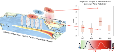
- uncover subseasonal-to-interannual predictability of extremes related to land-ocean teleconnections through Rossby wave propagation in the atmosphere
WACCEM research will enhance a predictive and process- and system-level understanding of water cycle variability and change and extreme events by advancing capabilities to design, evaluate, diagnose, and analyze global and regional simulations informed by observations. The Energy Exascale Earth System Model (E3SM) will be the primary modeling tool serving as a key component of a model hierarchy spanning dynamical models, cloud-resolving and Large-eddy simulations, global climate models, and machine learning models. We will enhance the use of E3SM by adding new capabilities (data assimilation, numerical tracers, slab ocean), developing an E3SM model hierarchy, developing and evaluating different E3SM model configurations, developing new metrics and datasets, and designing novel model experiments for hypothesis testing and causal discovery. Collectively, our efforts centering on E3SM will enhance the use of E3SM toward a “digital Earth” that supports scientific discovery.


