Enabling Ocean Feature Analysis Using Data Reduction and Computer Vision Methods
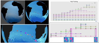
As computational capabilities have increased, so too has the resolution (both temporally and spatially) at which ocean simulations are conducted. However, there are limitations, both computationally and of the scientists' time, that limit the amount of data that can be post-processed for scientific discovery. We present a framework that takes advantage of a data reduction method known as image proxies combined with scientifically-driven computer vision techniques to detect, track and analyze ocean features through a semi-automated process.
The presented framework allows ocean scientists to explore large regions of the ocean, capturing movement and evolution of scientifically-relevant features over many time steps and large spatial regions. Such analysis, which would be difficult or impossible to conduct through traditional methods, is made possible and fast within the provided framework.
Today’s supercomputing capabilities allow ocean scientists to generate simulation data at increasingly higher spatial and temporal resolutions. However, I/O bandwidth and data storage costs limit the amount of data saved to disk. In situ methods are one solution to generate reduced data extracts, with the potential to reduce disk storage requirement even for high spatial and temporal resolutions, a major advantage to storing raw output. Image proxies have become an efficient and accepted in situ reduced data extract. These extracts require innovative automated techniques to identify and analyze features. We present a framework of computer vision and image processing techniques to detect and analyze important features from in situ image proxies of large ocean simulations. We constrain the analysis framework in support of techniques that emulate ocean-specific tasks as accurately as possible. The framework maximizes feature analysis capabilities while minimizing computational requirements. We demonstrate its use for image proxies extracted from the ocean component of Model for Prediction Across Scales (MPAS) simulations to analyze ocean-specific features such as eddies and western boundary currents. The results obtained for specific data sets are compared to those of traditional methods, documenting the efficacy and advantages of our framework.

