Mapping the Impact of Freeze Events on Aspen Health with Satellite Data
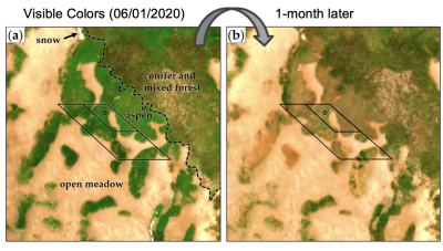
This study used satellite imagery to detect and map damage to quaking aspen forests in Southern Utah caused by an unusual freeze during the growing season. By tracking changes in vegetation health, the research identified areas most affected by the freeze, helping to better understand how these forests respond to climate extremes.
This research is important because it introduces a new way to monitor and understand the impact of early-summer freeze events on forests using satellite technology. By identifying vulnerable areas more precisely, the findings can help improve forest management and conservation strategies, particularly in response to changing climate conditions.
Aspen forests in western North America are highly sensitive to environmental changes, with growing season freeze events causing significant damage such as defoliation and reduced tree health. This study represents the first attempt to detect and map freeze-induced damage to aspen forests in Southern Utah using satellite-based methods combined with weather station data. By analyzing vegetation health changes through the Normalized Difference Vegetation Index (NDVI), researchers tracked the effects of a freeze event in June 2020, identifying the most impacted areas. The study also linked the onset of aspen growth to accumulated growing degree days, providing insights into the timing and vulnerability of these trees to freeze events. This research marks an important advancement in using remote sensing to monitor forest health across large areas. The findings can help land managers better identify and respond to climate-induced stressors, contributing to the protection of these critical ecosystems as climate variability increases.

