Evaluating Contemporary and Future-Scenario Substantial-Precipitation Events in the Missouri River Basin Using Object-Oriented Analysis
We examine extended (≥30-day) and short-term (≥5-day) periods of substantial precipitation in the Missouri River Basin, the largest single river basin in the U.S. Our focus is on extended periods of substantial precipitation above the 75% level for monthly precipitation. We examine short-term events above the 95% level to assess the degree to which our extended-period events are the outcome of an accumulation of shorter, very wet periods. Both types of events can be climate-impact drivers that affect human and natural systems. We diagnose the events using an object-oriented methodology (specifically, Tempest Extremes) where the “objects” are precipitation events exceeding specific thresholds. Input data comes from PRISM observations and two sets of contemporary (1981-2000) and RCP8.5 scenario (2041-2060) climate simulations by RegCM4 driven by either the GFDL or MPI GCM for the North America CORDEX program.
The Missouri River Basin is the largest single river basin in the United States, with an area over 1.3 million km2. It includes over 25 Native American tribal lands and parts of 10 U.S. states and 2 Canadian provinces, The basin plays an important role in many natural and human systems, such as wetlands, waterfowl migration, agriculture, hydroelectric power, transportation, recreation, and general water resources; these all contribute to the economic activities of the region. For example, the basin’s agriculture provides nearly half of U.S. wheat production, as well as substantial amounts of corn and soybeans.
There have been few comprehensive studies of the hydroclimate of this basin, even though the basin experiences substantial variability between drought and flooding conditions that can have a substantial impact through habitat degradation, flooding, crop loss, and other economic disruption. This work complements previous studies and more commonly reported regional percentile exceedances and intensity–duration–frequency curves by its event-based approach. We assess the frequency, spatial extent, duration, and other characteristics of these events in observations and regional climate simulations, all of which can guide how water is managed in the basin in future climate.
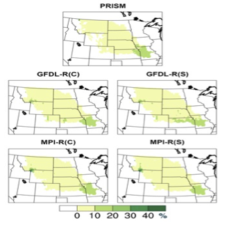
The simulated contemporary-climate events agree well with the PRISM events’ frequency and duration, although the simulated event areas tended to be larger than the areas in the PRISM events, suggesting that the effective resolution of the simulations is greater than the simulations’ 25 km grid spacing. Otherwise, spatial distributions of the extended-period events are similar in observations and contemporary-climate simulations. Except for some differences in the northwestern mountainous part of the basin, the highest frequencies are concentrated in the southeastern end of the basin, which is the part closest to a major source of atmospheric water, the Gulf of Mexico, and where temperatures are generally warmer, which can allow for more precipitable water. In addition, the events occur primarily during the warmer months of April–September and are substantially less frequent during the colder months of October–March, with implications for when flooding might occur due to extended periods of rainfall.
The contemporary and scenario climates in the simulations examined have largely unchanged event areas and durations, an important consideration for future water management of the basin. Interestingly, although the basin’s average precipitation increases in the scenario climate, the extended-term events showed little change in frequency, whereas the short-term events did increase in frequency by an amount commensurate with the increase in mean precipitation.
About half of the extended-period events had an embedded short-term event, usually just one. There were substantial differences between extended-period events containing a short-term event and those without one. Extended-period events with an embedded short-term event generally have larger areas, longer durations and more intense precipitation compared to their counterparts with no embedded short-term events. Such information could be useful for water managers assessing the evolution of extended periods with substantial precipitation.

