Assessing the Importance of Spatial Scale in Long-Term Land-Use Modeling over the Midwestern United States
As the land-use models used for understanding climate change mitigation and adaptation responses increase in sophistication, the spatial scales have become more resolved. In addition to allowing finer scale analysis of land-use trends, increasing spatial resolution may also lead to different model outcomes at regional and global scales.
A study by DOE researchers at Pacific Northwest National Laboratory isolated the impacts of increased resolution on regional-scale model outcomes in the agriculture and land-use component of PNNL’s Global Change Assessment Model.
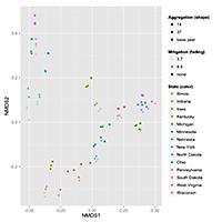
The work presents a new method for visualizing and analyzing the data from land-use models, which typically contain too many output variables to be assessed simultaneously. To address this problem, the team applied statistical methods developed by ecologists for analyzing ecosystem differences across environmental gradients to model output, using a set of scenarios differentiated by land-use region size and greenhouse gas emissions mitigation levels. Specifically, non-metric, multidimensional scaling is applied to a pair-wise distance matrix, collapsing variability along eight different land-cover classes and six scenarios into a two-dimensional coordinate plane. The study demonstrated that land-use regions in GCAM should be climatically and physio-graphically homogeneous to prevent infeasible transitions in land-use types. They found that for studies focused on broad-scale trends, there is little apparent benefit to push enhancements in spatial resolution. In future studies, the team will focus on the importance of country-to-region assignments in land-use and energy modeling, and the consequences of such groupings for future emissions mitigation assessments.


