Connecting Large-Scale Meteorological Patterns to Extratropical Cyclones in CMIP6 Climate Models Using Self-Organizing Maps
Extratropical cyclones (ETCs) are responsible for the majority of cool-season extreme events in the northeastern United States (NEUS), often leading to high-impact weather conditions. Evaluating the ability of climate models to adequately simulate ETC dynamics is essential for improving model performance and increasing confidence in future projections used by stakeholders and policymakers. Using a cyclone tracking algorithm (TempestExtremes) and self-organizing maps (an unsupervised machine learning approach), we can identify key patterns associated with historical ETC activity. These reanalysis-derived patterns are then used to evaluate the skill of CMIP6 historical experiments in simulating large-scale synoptic environments and associated cyclone activity.
Winter storms can have devastating socioeconomic impacts across the United States. Climate models are used to understand and predict these winter storms and how they might change in the future, therefore helping to inform climate policy, risk mitigation strategies, and regional emergency service needs. These climate models need to be evaluated so that their performance and accuracy can be validated and, if needed, improved. This article aims to characterize the large-scale meteorological patterns associated with winter storm activity in the NEUS and evaluate the ability of climate models to reproduce these patterns.
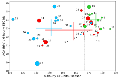
Automated cyclone tracking and self-organizing maps, a machine learning approach, are used to automate the process of identifying key patterns associated with historical winter storm activity. These patterns are then used to assess if CMIP6 climate models can reproduce the same synoptic patterns including the winter storm frequency and intensity. The results show that, while model resolution has some impact on simulation credibility, model configuration appears to be more important in representing large-scale patterns. Most CMIP6 models struggle to simulate patterns considered more "extreme" and tend to favor weaker patterns that are not as conducive to cyclone formation. As a result, most models simulate too few winter storms. At the model level, the error in simulated storm intensity is even more varied, with some models producing stronger storms and others producing weaker storms when compared to historical observations.

