Alaskan Soil Carbon Stocks Have Large Spatial Variability and Dependence on Environmental Factors
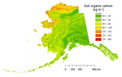
Soil organic carbon (SOC) can be a source or sink of atmospheric carbon dioxide, with the current balance depending on climate, disturbance, soil characteristics, and vegetation. Reliable estimates of regional SOC stocks and their spatial and temporal variability are essential to better understand controls of SOC stocks and their vulnerability to changing climate. Of particular concern are high-latitude SOC stocks, which are preserved, in large part, because of low temperatures. High latitude regions are expected to experience much higher temperature increases than temperate or tropical regions over the next century and therefore are a potentially vulnerable component of the global carbon cycle. Although uncertain, the total amount of frozen carbon in permafrost soils is estimated to be double that currently in the atmosphere. Further, the direction and magnitude of the SOC changes in response to climate change are very uncertain, and depend on the spatial and vertical distributions of SOC. In this paper, we estimated spatially resolved SOC stocks from surface to the C horizon, distinguishing active-layer and permafrost-layer stocks, based on geospatial analysis of 472 soil profiles and spatially referenced environmental variables for Alaska. We also provide estimates of the amount of permafrost carbon that could be thawed and made vulnerable to decomposition over the next century.
Total Alaska SOC stock was estimated to be 77 Pg, with 61% in the active-layer, 27% in permafrost, and 12% in non-permafrost soils, with very large spatial variability. Temperature and soil wetness were primary controllers of SOC stocks; secondary controllers, in order of importance, were land cover type, topographic attributes, and bedrock geology. Under strict caveats and assuming temperature changes from the IPCC A1B emissions scenario, we predicted that the average 2100 Alaskan active-layer depth could deepen by 11 cm, resulting in a thawing of 13 Pg C currently in permafrost. These values are at the lower end of those predicted by Earth System Models. The equilibrium SOC loss associated with this warming would be highest under continuous permafrost, followed by discontinuous, isolated, and sporadic permafrost areas. Our high-resolution mapping of soil carbon stocks and their relationships with climate, soil properties, topography, and bedrock geology reveals the vulnerability of high-latitude soil carbon and can be used as a basis for improving the land components of Earth System Models.

